3D scanning · Scan-to-BIM · As-built drawings

Know your building.
Plan with confidence.

Measured documentation your team can design, coordinate and build from. Capture the existing building so your next decision starts with what’s there today.

For architects, contractors, owners, preservation teams and institutions planning renovation, coordination or a lasting building record.

See what you’ll receive
REAL PLACES. MEASURABLE DETAIL.Clarity starts on site.
25 years

Founder George’s
industry experience

2.5 million sq ft

Digitized by LaserScanned
in the past year

Capture + model + drawings

One measured source. Three ways to use it, as scoped.

A BETTER STARTING POINT

Old plans leave questions.
Capture what’s there today.

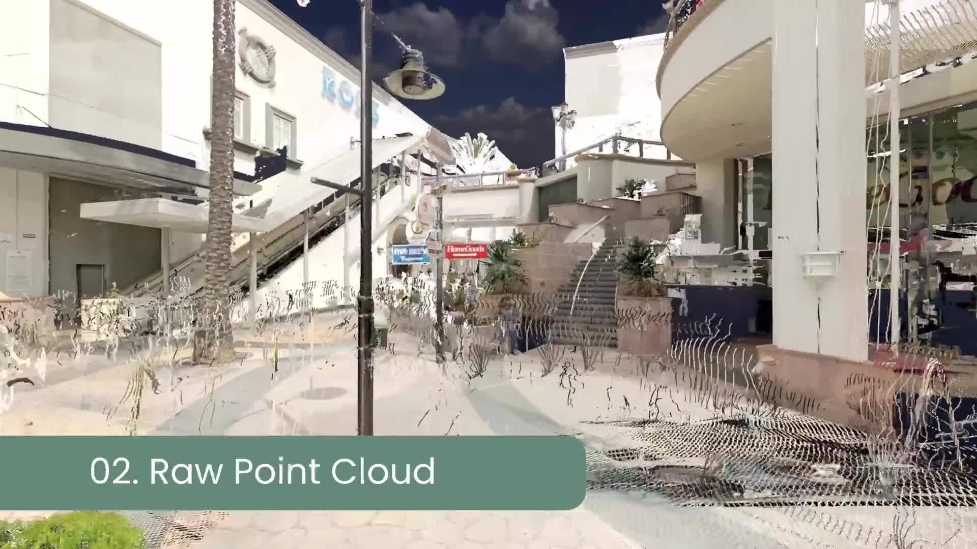
Explore the building as a color point cloud.
01

Stop designing around assumptions.

Ground design and prefabrication in measured existing conditions, including levels, openings and clearances.

A measured starting point
02

Bring the site back to the desk.

Reopen the point cloud to check a dimension, level or clearance without relying on scattered notes or another site visit.

More information within reach
03

Give everyone the same picture.

Architects, engineers, contractors and owners coordinate against one registered dataset of the building.

A clearer basis for coordination

THE COST OF NOT KNOWING

Find the condition.
Before it becomes rework.

An unrecorded beam. Too little ceiling clearance. A floor at the wrong level. When an existing condition reaches the team late, it can mean RFIs, standby time, recut material and a change order.

~5%

Field rework

Field rework often lands around ~5% of construction value (CII-type findings); worse on complex jobs.

48%

Data and communication

Autodesk / FMI: about 48% of rework tied to poor data and miscommunication.

30–60%

Condition-driven rework

Scanned jobs: industry summaries often cite 30–60% less condition-driven rework.

Where the risk deserves a closer look

  • Occupied interiors and above-ceiling work.
  • Mechanical rooms, shafts and congested MEP systems.
  • Hospitals and labs where shutdowns disrupt operations.
  • Historic fabric, irregular walls and out-of-plumb conditions.
  • Façades and additions that must meet existing geometry.

What scanning changes

  • Design and prefabrication start from captured visible geometry.
  • The team can check dimensions in the cloud when RFIs arise.
  • Scoped BIM models support coordination against existing structure and services.
  • The owner keeps a dated record for future work.

One clash can carry several costs.
One clash (standby + rush engineering + scrap + general conditions) routinely costs more than the scan.

Get a scanning quote

Scanning records visible, accessible surfaces. It does not uncover every hidden condition or prevent every change order.

FROM REAL SPACE TO USEFUL INFORMATION

The right deliverable.
For your next step.

Start with the next decision: a cloud your team can measure, a Revit model for coordination, or drawings for planning. One scan can support all three; modeling and drawings are scoped separately.

A house represented as a point cloud with building lineworkPOINT CLOUD / EXISTING GEOMETRY

3D LASER SCANNING

A measured building your team can revisit.

A registered color point cloud of visible surfaces. Open it in compatible software to measure distances, heights, levels and clearances, clip views, or cut sections as new questions arise. Setup imagery adds context to the measured geometry.

Who it’s for
Design teams drafting or modeling in-house; owners who need a reusable site record.
What you receive
A registered point cloud in agreed formats such as RCP or E57, with setup imagery and a viewing package as scoped.
When to choose it
Choose capture when your team can work directly with the cloud, or when modeling and drawing needs will be decided later.

Coverage, access, accuracy expectations, imagery and file formats are agreed before capture.

Get a scanning quote
Color scan and Revit building model with a FARO scannerSCAN-TO-BIM / EXISTING CONDITIONS

SCAN-TO-BIM

A Revit model built from your scan.

Turn the registered point cloud into a structured Revit model built from the scan, rather than traced from old CAD. Architecture, structure and MEP are included as scoped. Modeling is reviewed against the cloud so your team can trace the model back to the measured building.

Who it’s for
Architects, engineers and contractors coordinating design, MEP or prefabrication in BIM.
What you receive
A Revit model at the agreed Level of Development (LOD), plus the source point cloud. Add 2D sheets from the model when scoped.
When to choose it
Choose Scan-to-BIM when the next phase needs modeled building elements for design or coordination, or an owner needs a reusable building model.

LOD, disciplines, modeled elements, tolerances and software version are agreed in writing. A coordination model and a fabrication-level model require different scopes.

Get a Scan-to-BIM quote

AS-BUILT DRAWINGS

Existing conditions, clearly drawn.

Plans, elevations, sections and reflected ceiling plans drafted from the registered scan. Dimensions follow the captured geometry, including irregular conditions. We agree the sheets you need for the next phase.

Who it’s for
Architects and project teams working in 2D; owners and preservation teams needing documented existing conditions.
What you receive
DWG and PDF sheets as agreed. The point cloud can be included as an additional record.
When to choose it
Choose drawings when the immediate need is a 2D reference for planning, permit design or preservation documentation.

Required sheets, coverage and formats are agreed in the scope. Existing-conditions drawings support the design process; they are not automatically a complete permit package.

Get a drawing quote

CAPTURE THAT FITS THE BUILDING

What we capture when the job needs it.

01

Interiors

Rooms, circulation, stairs, shafts and visible structure.

02

MEP and mechanical rooms

Congested equipment, racks and accessible services that affect coordination.

03

Exteriors and façades

Courtyards, additions and site context, with elevated or long-range setups where access allows.

04

Occupied buildings

Capture planned around how the building is used, with setup density and detail matched to the scope.

05

Historic fabric

Non-contact capture of irregular walls, ornament and out-of-plumb conditions.

Visible surfaces, within the agreed scope. A scanner does not see through walls, closed ceilings or stored materials. If a plenum or covered elevation matters, we plan access before capture.

Not sure what you need? Tell us about the project. We’ll help you choose.Let’s work it out

EXPERIENCE YOU CAN BUILD ON

Led by George. Grounded in 25 years of experience.

George, founder of LaserScanned
George

Founder, LaserScanned

25years of
industry experience

Behind every scan is a real building, a project team and a decision that matters.

George, founder of LaserScanned, brings 25 years of industry experience to the work. His approach starts with your next decision: define the right scope, capture what matters and deliver documentation your team can use.

In the past year alone, LaserScanned digitized 2.5 million square feet. That experience comes from existing buildings, real access constraints and files that need to work with the project team’s software.

01

Your project comes first. Start with the decisions you need to make, then agree what needs to be captured.

02

Clarity before capture. Define the coverage, level of detail and deliverables before the work begins.

03

Information with a purpose. Keep the output connected to design, coordination, permitting or the long-term building record.

Tell us about your project

A CLEAR PATH FROM SITE TO FILE

Three steps.
One informed starting point.

A written scope, a planned site visit and files your team can open. We make each step clear before work begins.

01

Define the project.

Share the location, approximate size and what you are planning. We agree interior, exterior and MEP coverage, access constraints, deliverables and level of detail.

You get: a written, project-specific scope
02

Capture the building.

We plan around occupied areas and site access. Faster coverage setups and more detailed capture are chosen for the agreed use, with elevated or long-range positions where needed.

You get: a registered point cloud of the agreed coverage
03

Put the information to work.

Receive the cloud and, if scoped, the Revit model and 2D drawings. The same measured source supports the files your team needs for the next phase.

You get: the agreed cloud, model and/or drawings

Have a deadline? Include it in your request so timing can be discussed with your scope.

BUILT AROUND YOUR NEXT DECISION

Different roles.
A shared need for clarity.

01

Architects & designers

Start renovation or alteration with measured existing conditions to draft and model against.

02

Contractors & project teams

Use a shared site reference for coordination, prefabrication and field discussions. Add progress scans when scoped.

03

Property owners & managers

Keep a useful record for capital work, leasing, maintenance and the next consultant.

04

Preservation teams

Document irregular historic fabric without contact to support restoration and adaptive reuse.

05

Institutions & campuses

Give facilities teams and consultants a shared building record for schools, museums, healthcare and civic sites.

06

Engineers & MEP coordinators

Check visible structure, services, equipment and clearances when new systems must fit existing space.

BEFORE WE GET STARTED

Good questions.
Clear answers.

Have a specific building or deliverable in mind?

Ask the team
What if I don’t know which service I need?

Tell us what you are planning and who will use the information. We can help scope a point cloud, a BIM model, drawings or a combination. Some projects capture first and define modeling or drawing needs once the cloud is available.

What’s the difference between a point cloud, BIM and drawings?

A point cloud is a registered set of measured points on visible surfaces. A BIM model turns selected building elements into structured 3D objects at an agreed Level of Development. Drawings communicate existing conditions in 2D. Modeling and drawings have their own scope, even when delivered with the scan.

Do I need Scan-to-BIM, or is a point cloud enough?

Choose a cloud when your team can measure, draft or model from it directly. Choose Scan-to-BIM when the next phase requires modeled elements for Revit coordination, design or prefabrication. We agree LOD, disciplines and tolerances in writing so the model fits the intended use.

What do you need to prepare a quote?

Location, approximate area and the output you need. If you are unsure, say so. Building type, occupancy, access limits, existing plans, MEP or historic complexity, exterior coverage and your deadline help define the scope.

How much does a project cost, and how long will it take?

Both depend on size, complexity, access, coverage and deliverables. Detailed modeling adds work beyond point-cloud capture. Mechanical rooms and historic fabric need a different approach from an open floor plate. Send the project details for a quote and schedule.

Can you scan an occupied building?

Often, yes. We plan around activity, privacy, access and visibility, and select capture setups to suit the required detail. The scanner records visible surfaces; it does not see through walls, closed ceilings or stored materials.

Do you scan exteriors, façades and site context?

Yes, when included in the scope and accessible. We plan positions for façades, courtyards, additions and site context, including elevated or long-range setups where appropriate.

Which areas do you serve?

LaserScanned is based in Simi Valley and serves the Los Angeles area. Include the project location so availability and travel can be confirmed.

Will the files work with my design software?

Tell us your software, version and required formats. Common workflows include Revit, AutoCAD, ReCap and Navisworks; cloud, model and drawing formats are agreed before work begins.

Does a scan prevent all change orders?

No. Scanning cannot reveal inaccessible hidden conditions, prevent scope changes or remove every design and construction risk. It helps your team check captured existing geometry earlier, reducing reliance on assumptions. The benefit depends on coverage, access, model scope and how the team uses the data.
START WITH WHAT’S REALLY THERE

Your next project.
A clearer foundation.

Tell us about the building. We’ll help define the capture and, if needed, a model and drawings your team can use.

Project-specific scope. No obligation.
Let’s talk about your building.Free quote

About your quote request

This form sends your email address and project details to LaserScanned through Mailchimp. Submitting requests a quote and subscribes you to LaserScanned email updates. Mailchimp may ask you to confirm your email address. You can unsubscribe using the link in those emails.

For questions, contact info@laserscanned.com.